Build your dream home
Beautiful off-grid land in the Aeneas Valley, Okanogan County, WA, is waiting for you
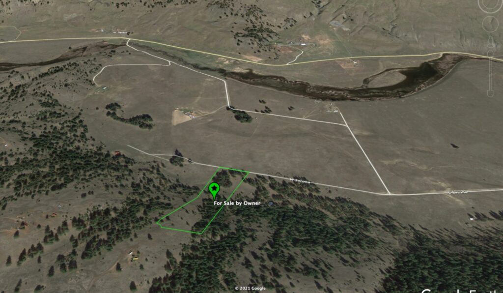
This property is located at the feet of rolling hills. There is enough flat space to build a house of any size. This property features a number of trees on the hill. Nearly 10 acres with a nice mix of meadow and trees. Fantastic views of the Aeneas Valley.
Watch this 3 Minute Drone Flight over the land!
Relax and breathe Free on your off-grid land
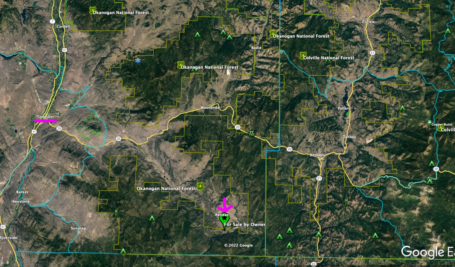
Situated in the heart of the Aeneas Valley, our property offers far-reaching views of gently rolling mountains above and a quiet valley below. This property is located in the State of Washington in the Okanogan County (South of the Canadian border).
Here you will find the ideal place to build your dream home. Flat at the road for approximately 1/3rd of the land, it is covered by grass, flowers and a few tall trees. Here you can build a house of any size and enjoy views of the valley. Beyond the flat area where one can build a substantial house lies a gradually sloping hill that affords picturesque views of the valley below. The hill is easy to climb and is not steep as there are several flat spots where one one can rest and meditate.
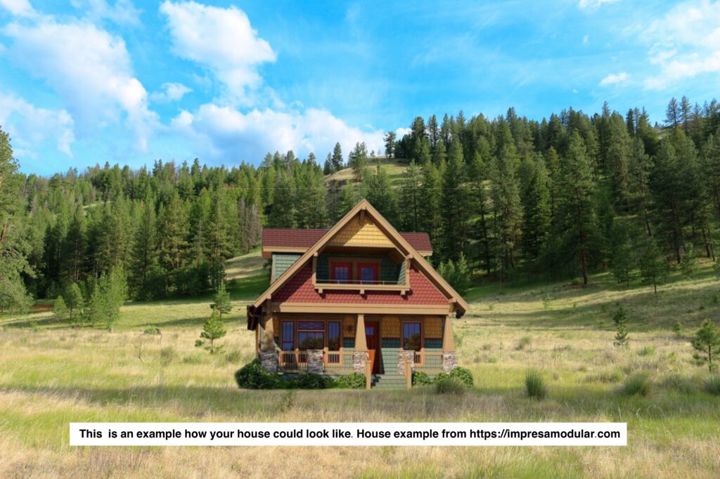
The land is zoned residential and you are free to build your own house or, if you prefer, a cabin. You can also use the property to set-up temporary accommodation such as a RV or a mobile house or even a camping tent until you build a house.
When you buy the property, you will automatically become a member of the Sun Ranch Owners’ Association. Their annual dues are only $120. This amount not only covers the maintenance of the graveled roads but also allows you unlimited access to their “headquarters” area where you can shower, shave and clean up as well as gather all the water you need to bring back to your property until you drill your own well.
This is a rare offer at a rare price in today’s rapidly changing market! You are unlikely to get a better deal at a time when many are moving to the countryside.
Contact me now: email kerstin@sunlandviews.com,
phone (747) 262-3161 (Please leave a message if I don’t pick up the phone)
Where is the property located?
W Sorona Way, Tonasket, Washington State 98855, USA
Driving from Tonasket to the property will take 40 minutes.
How can I find the property?
20 miles from Tonasket (the nearest town)
- Get on the WA-20 E/6th St E
- Turn right onto Aeneas Valley Rd
- Turn right onto Watoka Way
- Turn right onto W Sorona
- Parcel Number and Owner: 6034160000, Kerstin Knuepfer
- Lat/Long: 48.534138, -118.971543
To locate the exact parcel, we recommend that you first install onxhunt.com on your phone (preferably at home before you drive to the land to check it out). The app onxhunt, which uses satellite, can show you the precise boundaries of your property.
Please watch this video. We will explain exactly what you need to do to identify the correct property. In the area is no internet connection and you will not be able to access google maps on your phone. That’s why it is very important that you follow the instructions step by step in this video.


Sun ranch owners' association
The Sun Ranch Owners’ Association oversees the maintenance, repair, and upkeep of the roads, the “headquarters” and other common areas. As soon as you buy the plat, you automatically become a member of the Association. The Association owns the common areas of the plats, including the headquarters property, which is situated between Cape Labelle plat and Lyman Lake plat on Aeneas Valley Road. The “headquarters” area is where members meet for annual meetings, and members are welcome to use the shower rooms and internet connection as well as obtain water. https://www.sunranchtonasket.org/
All roads within the easements defined on the plats are private and are intended to provide fundamental, unrestricted access to the individual lots. The easements also provide unrestricted access for public utility services. The Association maintains these roads in a passable condition

You can download the covenants and bylaws here: https://www.sunranchtonasket.org/covenants-and-bylaws
There are very few rules. An excerpt of the most important regulation:
- Lots may be used only for recreational and residential living purposes, and related agricultural or livestock uses. No commercial use.
- A permanent dwelling structure must have a minimum floor area of 500 ft.².
- Occupation of a mobile house trailer, camper, or other temporary shelter as a temporary residence is subject to the approval Sun Ranch of the Board of Directors.
- Properties must be maintained in clean, safe, and attractive condition, and in good repair.
Overview
Property
- State: Washington
- County: Okanogan County
- Address: W Sorona Way, Tonasket WA, 98855,
- GPS: 48.534138, -118.971543
- Description: LOT 416 LYMAN LAKE RANCHES OF SUN RANCH
- Size: 9.73 Acres
- Parcel Number: 6034160000
- DOR Code: 91 – Undeveloped – Land
- Title: Free & Clear, Special Warranty Deed
- Zoning: Residential
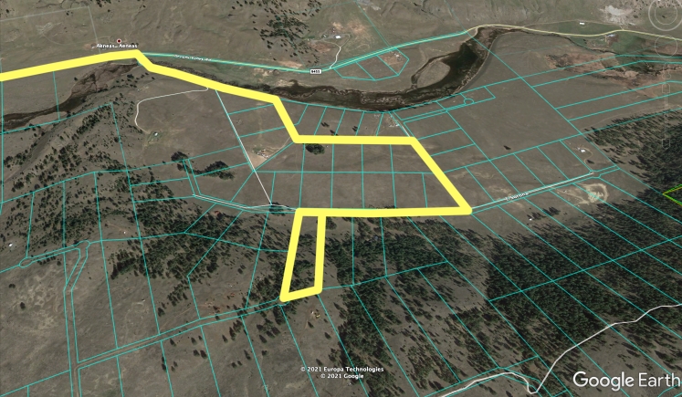
- Terrain: Approximately 2 acres of the property is flat land. This is the front area at the street. Here is the ideal place to build your house or cabin. After the flat land it gently slopes towards the top.
- Trees: Many trees on the top part of the parcel
- Elevation: approx. 2,400 ft at the street level; approx. 2,800 ft on top of the hill
- Taxes yearly: $320.74
- Sun Ranch Owners’ Association, yearly dues: $120.00
- Road: The Sun Ranch Owners’ Association maintains the dirt roads all year round
- FEMA Flood Zone: No flood zone
- Width of front side: 300 feet
- Width of back side: 324 feet
- Length of left side: 1350 feet
- Length of right side: 1474 feet
- Land Survey: hasn’t been surveyed, before building or putting up fences, a professional survey needs to be done
Utilities
- Electricity: You can obtain stable power by installing portable generators or/and solar panels.
- Water: You can access the water from the “headquarters” area of the Sun Ranch Owners’ Association. Alternatively, you can drill a well.
- Well: There is no well but you can let it drill. The neighbors well at the same lavel is 138 feet deep.
- Sewer: you need to install a septic system if you build a permanent house
- Phone: you can obtain a phone line
- Internet: Internet is available at the Sun Ranch Owners’ Association’s “headquarters” area.
Housing
- Mobile Homes, Cabins and Houses: your home needs to be bigger than 500 sqft in order to get a permit from the Sun Ranch Owners’ Association
- Camping: No restrictions on camping for a tent or RV
- Neighbors: The property on the left side has a vacation cabin; on the right side, there is a house with a couple who lives there the year round
Terms
- Payment: Cash or Conventional Loan but no payment over time
- Due Diligence: Buyer is responsible for all due diligence prior to purchase.
Parcel and topography
The Area
Schools
There is an Elementary, a middle and a high school in Tonasket.
Shops
There are many shopping options in Tonasket. Here I just list my personal favorites:
- Twisp Farmers Market, methowvalleyfarmersmarket.com
- Tonasket Natural Foods Co-op, tonasketcoop.com
- Rooster’s Espresso, the best coffee in town facebook.com/RoostersEspresso/
Churches
There are at least 15 churches, alone in Tonasket, several more in the other close by tows like Omak, Oroville and Republik
- Tonasket Community Church Ucc
(509) 486-2181, 24
W 4th St, Tonasket, WA 98855 - Assembly of God Church
(509) 486-2949, 25
W 4th St, Tonasket, WA 98855 - Tonasket Foursquare Church
509) 486-2000
415 S Whitcomb AveTonasket, WA 98855 - Free Methodist Church
(509) 486-2194
10 W 6th St, Tonasket, WA 988555 - Seventh Day Adventist Church
(509) 486-2752
23 S Whitcomb Ave, Tonasket, WA 98855 - Hope Lutheran Church
(509) 486-2254
623 S Whitcomb Ave, Tonasket, WA 988557 - Tonasket Mennonite Church
(509) 486-0610
513 Highway 7
Tonasket, WA 988558 - Tonasket Free Methodist Church
(509) 486-2194
1 Stanton Loop Rd, Tonasket, WA 98855 - First Baptist Church
(509) 486-2077
31614 Highway 97, Tonasket, WA 98855 - Ellisforde Church Of Brethren
(509) 486-4531
3216 Highway 97, Tonasket, WA 98855 - First Baptist Church Of Omak
(509) 826-4141
Po Box 397, Tonasket, WA 98855 - Seventh-day Adventist Church
(509) 486-4345
32084 Highway 97, Tonasket, WA 98855 - Immanuel Lutheran Church
(509) 485-3342
1608 Havillah Rd, Tonasket, WA 98855 - Aeneas Valley Church
(509) 486-0400
9 Gooseberry Way, Tonasket, WA 98855 - Peaceful Valley Christian School
(509) 486-4345
32084 Highway 97, Tonasket, WA 988
Demographics
Tonasket city, Washington
Surrounded by Okanogan National Forest and Coleville National Forest

Okanogan County¹
Okanogan Country is part of the North American Pacific Flyway for migrating birds making bird watching opportunities for song birds, game birds, water birds and raptors legion.
Birders of all levels from novices to the professional can find a truly delightful experience in Okanogan Country. We have a wide diversity in landscape and climate that attracts birds to our area. Our numerous lakes and rivers attract waterfowl and shorebirds. The high deserts and alpine meadows attract a variety of songbirds and upland birds. So whatever type of birding you like, Okanogan Country has it for you. With hundreds of species of indigenous and migratory birds, bird watching can be very rewarding. To learn more about Washington birdwatching opportunities, take a look at some of the locations below.
(1) Text from https://okanogancountry.com/birdwatching–wildlife-viewing”
Colville National Forest²
During President Theodore Roosevelt’s two terms in office, he set aside millions of acres of forest reserves. Roosevelt proclaimed sixteen million acres of new reserves, sometimes referred to as midnight reserves, before signing an appropriations bill from Congress that would prohibit the President from creating any new forest preserves in those states. The Colville Forest Reserve, created on 1 March, 1907, was thus created.
The Forest boundary, a part of the Pacific Northwest Region (Region 6), included 700,000 acres of lands north of the Colville Indian Reservation to the Canadian Border, and was bounded east and west by the Columbia and Okanogan rivers, respectively. The first headquarters office was on Main Street in Republic, WA with W.W. Cryder as the Forest Supervisor.
Presently, the Colville National Forest has 1.5 million acres in north eastern Washington and includes the Kettle River, Selkirk mountain ranges, and the upper reaches of the Columbia River. The forest has four ranger stations and a supervisor’s office that govern the forest’s five districts: Three Rivers Ranger Station in Kettle Falls, Republic Ranger Station in Republic, Tonasket Ranger Station in Tonasket, Newport-Sullivan Lake’s Station in Newport, and Newport-Sullivan Lake’s Station in Metaline Falls.
The greater populated areas close to the Colville National Forest and within the US perimeter are Ferry, Stevens, Okanogan and Pend Oreille Counties, the Kalispel Indian Community of the Kalispel Reservation, the Confederated Tribes of the Colville Reservation, and the Spokane Tribe of the Spokane Reservation.
Residents and visitors enjoy the Colville National Forest’s wild huckleberries, camping, hiking trails (486 miles), OHV trails, mountain biking, horse trails, lakes, rivers, and streams. The forest also boasts exciting wildlife such as the grizzly and black bears, cougars, bald eagles and the last remaining herd of caribou in the U.S.
Nearby attractions also include Little Pend Oreille National Wildlife Refuge and the Lake Roosevelt National Recreation Area.
(2) Text from https://www.fs.usda.gov/main/colville/about-forest
Tonasket Ranger District ³
Tonasket Ranger District’s 415,000 acre landscape covers five distinct blocks, or areas, across the eastern half of Okanogan County in North Central Washington; bordered on the north by Canada and the southwest by The Colville Indian Reservation. The largest contiguous block is west of the Okanogan River. It includes the northeast corner of the Pasayten Wilderness and shares a boundary with the Methow Valley Ranger District. The Buckhorn, Mount Hull, Bonaparte and Aeneas blocks make up the east side of the District.
Grass and shrubs dot the lower elevations, climbing to beautiful ponderosa pine forests at mid-elevations, then Douglas-fir/western larch, and the subalpine and alpine forest at elevations above 6,000 feet.
More than 180 miles of trail are maintained for hikers, horseback riders and motorized recreationists. There are several developed campgrounds as well as a lot of opportunity for dispersed recreation.
With fairly long travel distances from major northwest population centers, the District is considered a bit of a well kept secret by those who make the journey. Whether it is June when the colorfull hillsides of Horseshoe Basin are a riot of color with wildflowers in bloom or in January when the glittering snow at Highlands snow park sparkles in the sunshine, the National Forest lands managed by Tonasket Ranger District offer a chance to stop, take a deep breath and feast on the Natures Glory.
(3) Text from https://www.fs.usda.gov/recarea/colville/recarea/?recid=83245
For your inspiration

Cash price:
41,900.00
We don’t offer payment over time.
There are some credit companies that give loans for raw land. We don’t have any affiliation with them. You can ask them for their rates: https://www.lightstream.com/
You can download the covenants and bylaws here: https://www.sunranchtonasket.org/covenants-and-bylaws
